Tuesday, July 31, 2012

Harran of the Sabians


    The ruins of Harran, which occupies the site of ancient Carrhae, are located some 40 Km South of the modern city of SanliUrfa, in South-Eastern Turkey. Amidst the vast crater of ruins, visible from many miles away, stands a high tower built of solid stone. This is all that remains of what was one of the major occult universities and mystery schools of the ancient world.

Harran - A view of the grand mosque, built in Umayyad period over the ruins of the ancient temple of Sin, with the tower of the Astrologers in the background - (Photo by Author)
     The name of Harran originally came from ancient Akkadian Harrānu, meaning “crossroad”
According to tradition, Harran was first founded by Nimrod, the legendary hero who was credited by Biblical scholars for building the tower of Babel. It was already a flourishing center by the 2nd millennium BC, famous throughout Mesopotamia and the Eastern world for its fabulous temple to the Moon-God Sin. King Nabonidos of Babylon, who was probably himself a native of Harran, turned the city into one of the major centers of his neo-Babylonian empire by the VII century BC, considerably enriching the great temple of Sin.

    In classical times, Harran could benefit from a relative stability due to its cushion status between the Roman empire and Parthia. Harran proved however unfortunate to many Roman rulers: Crassus was defeated just in front of its walls in the plain of Carrhae, while Emperor Caracalla was there assassinated  while going on a pilgrimage to the grand temple of Sin. Another Roman Emperor, Julian, died in a military campaign against the Sassanians in 363 AD, soon after paying his respects to the planetary gods of Harran.
Even in the late IV and V Century Harran was largely immune from the diffusion of Christianity throughout the Eastern Roman empire and became one of the major strongholds of classical paganism. After the edict of Theodosius (389 AD) and Justinianus (529 AD) and the destruction of pagan temples which followed, Harran was taken as a safe refuge by various Gnostic and hermetic sects which had become persecuted in the rest of the empire.
    According to 4th Century historian Libanius, “In the very middle of the city of Carrhae stood a magnificent temple, considered by many the equivalent to the Serapeum of Alexandria…In this temple was a very high tower, which was also used as an observation post because one could see the entire plain of Carrhae from its top… However, when the prefect Cinegius ordered the closure and destruction of all pagan temple in Syria and Egypt, this temple of Carrhae was also partially destroyed, and all of the idols and statues carried away.”
     Notwithstanding the destruction and the sack suffered by hands of the prefect Cinegius, by the early 5th Century the temple had been already reconstructed and paganism re-established to the point that the pilgrim Egeria, writing also in the 5th Century, could not find a single Christian in the whole city of Harran (“sed totum gentes sunt…”).

    The city was clearly established according to a Hermetic ground plan, closely resembling the ideal Hermetic city of Adocentyn whose description is contained in Picatrix. It too had seven gates dedicated to each of the planetary deities (Sun, Moon – considered equal to the planets – Mercury, Venus, Mars, Jupiter and Saturn) according to the principles of talismanic magic. It was circular in shape and had a large temple in its center surmounted by a high tower.
Not surprisingly, even after the rise of Islam and Arabic conquest, Harran became one of the major centers of Eastern and Western hermeticism. An important university was established in Harran as early as the 7th Century, where hermetic scholars were responsible for the re-collection and composition of the large, though widespread Corpus Hermeticum and of various hermetic treatises – most notably the Picatrix – dealing with talismanic and ceremonial magic.

    According to a famous legend, when Caliph Al-Mamum took the city in year 820 AD, the Harranites claimed protection on the basis of being one of the “people of the Book” mentioned in the Quran. When asked who they were, they responded: “we are Sabians”, thus escaping massacre; and adopted thereafter the Corpus Hermeticum as their sacred text.
The name Sabians is likely a derivation from the Coptic Saba’ia, meaning “people of the Stars”, likely a reminiscence of a very ancient star cult which had its roots in the ancient Egyptian religion, the cult of the Magi of ancient Persia and the western Hermetic tradition. The linkage between the Sabians of Harran and Egypt was made even stronger by their annual pilgrimage to the pyramids of Giza, quoted by several Arabic writers, which the Sabians believed were the tombs of Hermes Trismegistus and Agathodaimon built before the Flood.
A famous phrase, written over the main entrance door to the largest temple of Harran could still be read by Arabic historian Mas’udi in 943 AD: “Know yourself, and you will become God”...

    During the 8th Century, Harran briefly took over the role of capital of the Umayyad caliphate under Marwan II, which however lost in 762 when the capital was moved again to Baghdad by Abbasids caliphs. 
Harran survived as a major center of learning and scholarship throughout the 12th and 13th Century, until it was finally sacked and destroyed by Mongolian hordes in 1259, never to be rebuilt.
It happened thus that what for over 3,000 years had been one of the most prosperous and important cities in the ancient near East became a deserted ruin.

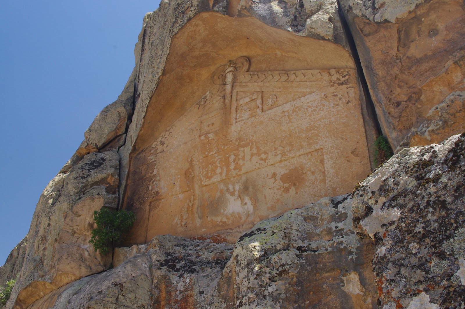
Harran - A giant arch is almost all that remains of the grand prayer hall built by Umayyad caliphs on the site of the Grand Mosque of Harran, a building comparable to the Mosque of the Umayyads in Damascus. One frequently finds broken fragments of columns, stelae and reliefs clearly belonging to more ancient temples dating as far as the Babylonian period - (Photo by Author)
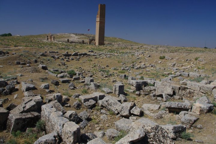
Harran - Amidst the vast crater of ruins, the tower of the Astrologers stands as high as 50 meters over the deserted plain, visible from many miles away. The tower was certainly used for astronomical observations and is the sole remain of the once fabulous temple of the Moon-god Sin - (Photo by Author)
    One barely recognizes amidst the vast crater of ruins which is today’s Harran the wrecked grandeur and magnificence of the ancient city. The most recognizable remain is now the grand mosque occupying the site of what was in ancient times the temple of Sin with its high tower of stone visible from many miles away. The only other notable remains is a vast castle considerably enlarged by Saladin and the Crusaders to the South-East of Harran, whose octagonal towers are most likely all that remains of an ancient temple of the Sabians dedicated to the planetary deities.


Harran - The ruins of the great castle date back to the early Byzantine period. It was later rebuilt by the Crusaders of Edessa and then again by Saladin.  The beautiful octagonal towers have nothing of the severe and austere style of medieval military architecture: they are probably the remnants of some ancient temple of the Sabians - (Photo by Author) 
    To add to the sense of mystery that sorrounds this city of the Dead, several authors have seen a connection between the tower of Harran and the Tower card – striken by bolts of lightning – in the Major Arcana of the Tarots. Another card of the Tarot, the Moon card also bears a close resemblance to a couple of nearby columns located in Sanliurfa and popularly indicated by the name of “Throne of Nimrod”, which were also closely associated to the worship of the Moon-god Sin (these are probably the same pillars mentioned by Jewish-Roman historian Josephus in the land of Siriad as the work of the sons of Seth from before the flood)


Harran - the great tower of the Astrologers overlooking the plain of Harran. Note the similarity with the Tarot card of the Tower struck by lightning...The tarot deck likely originated in the Islamic middle ages, and Harran was one of the major centers of learning and hermetic philosophy at the time - (photo by Author)


Sanliurfa (ancient Edessa) - The two ancient columns that overlook the ancient citadel of Urfa from the top of the acropolis are known by locals as the "Throne of Nimrod", since Nimrod had according to legend his palace on the hill of Urfa. The columns actually date to the 2nd or 3rd Century AD: a Syriac inscription reads "I am Eftuha, son of the Sun, I had these columns rebuilt for me and my Queen...". Recent excavations close to Abraham's pool at the bottom of the acropolis have revealed remains of civilization more than 11,500 years old - (photo by Author)

Saturday, July 28, 2012

Turkey's Marcahuasi: the mysterious City of Midas


Midas City - The intricate facade of Midas monument is elaborately carved into a square and crosses pattern. The entire structure is now covered in a 7-storey high scaffolding as the monuments is threatened by rain and wind erosion - (Photo by Author)
The “City of Midas” occupies a vast plateau in Central Anatolia close to modern Afyon and Eskisehir. Strange rock formations shaped in ancient times into monumental rock facades and unexplainable stairways and tunnels create a sense of mystery as if dominated by some kind of supernatural power. This is a place of power, where one truly feels the pulse of the Earth in a place which has been since time immemorial the sacred centre of Anatolia. In modern times, the plateau of Midas has been called “Yazilikaya”, which means the “inscribed rocks” – a very appropriate name indeed –

The “City of Midas” is by no means a city in the classical sense. It is a city of the Gods and spirits, not the dwelling place of ordinary people.  There are no houses nor buildings whatsoever. Even though the “City of Midas” is often called a fortress, there is not even a strip of wall to justify such a claim.
Everything there is made of rock and cut into the living rock, as if the rock itself was home to some kind of divine beings. As in Peru’s famous Marcahuasi plateau, odd rock formations take the shape of monstrous beasts and human forms. 

The most famous monument is the so called “Tomb of Midas”: even from a short inspection it is however clear it was never a tomb. The monument takes the shape of a giant rock-cut façade measuring over 16 meters in width and some 20 meters in height. There is a large portal in the façade, which however terminates in a false door which has been partly destroyed by robbers looking for some hidden treasures or chambers. This was most likely a doorway to the spirit world, bearing a close resemblance to other similar monuments in other parts of the world, most notably the famous Peruvian gateway of Aramu Muru close to lake Titicaca (which we also visited in 2007).
A large, yet undeciphered inscription occupies the top portion of the monument, where one clearly reads the name of Midas. It is not clear whether this Midas is the same as the legendary king of the Phrygians which is otherwise supposed to be buried in a large tumulus near Gordion. The inscription, in Phrygian alphabet, closely resembles the ancient Etruscan and runic writings.
The decoration of the façade is a very simple, yet strikingly beautiful geometric pattern made of crosses, triangles and squares. This is an extremely refined composition, which sharply contrasts with the otherwise crude character of Phrygian figurative rock sculpture. 
There is also an unfinished monument, very similar to Midas’, located a few hundreds meters from the main monument on the same rock cliff.

When reaching the top of the “acropolis”, one finds the most unexplainable features of Midas. There are hundreds of meters of stairways cut into the rock and leading nowhere or deep into the Earth, giant stepped altars and thrones. These stairways were clearly intended as ceremonial pathways, and one can sometimes find the fainted remains of reliefs and depictions of pilgrims and robed figures carved into the rock in a very crude and archaic style which  is likely Hittite or pre-Hittite.

Some of these stairways end abruptly on the edge of a cliff, or simply lead nowhere stopping in front of inaccessible rock walls and crevasses. But there are also stairways leading to tunnels deep into the ground of the plateau: these tunnels are of extremely accurate workmanship and have a vaulted ceiling similar to Hittite gateways and tunnels one also finds in Bogazkoy-Hattusas.  In some cases these tunnels intersect at vast underground chambers which, though often called “cisterns” or “underground reservoirs” were surely never used as such. Unfortunately the extensive deposits which have accumulated on the bottom of the tunnels and chambers do not allow to find where they ultimately lead or whether they were intended to serve some other yet unknown purpose.
Turkey is a place of many underground cities, so I will not be surprised if the “City of the Gods” of Midas was in fact another underground city which could only be reached by way of these monumental dwindling tunnels. Phrygians believed their Gods lived deep beneath their mountains: perhaps Midas was held as the original homeland of the Phrygian people and of their national Goddess Cybele whose name literally means “Mother of the Mountain”.

Around Midas’ mysterious city extends the sacred heartland of the Phrygian empire, in the so called “Phrygian valley”: there hundreds of rock-cut chambers, tombs, altars and stairways create one of the most elaborate ceremonial landscapes in the ancient world. This was clearly intended as a sacred and ceremonial space, which was as such deliberately avoided by permanent human settlement.
In some places, like at Aslantaş and Yazilikaya-Midas itself, one has the feeling that some obscure, yet devastating cataclysm ravaged the entire region turning it into a kind of barren and lunar landscape. Giant crevasses opened into the ground, collapsed stairways and tunnels are all evidence of sudden destruction and impending catastrophe. In Aslantaş one wonders at the powerful force of nature that cracked the rocks and made a ruin of the giant rock cut monuments and sanctuaries…

The city of Midas is conventionally dated to the VIII to VII Century B.C., but it may be of any antiquity. The style is somehow reminiscent of pre-Hittite and bronze age construction, but there are also elements such as rock cuts and cup marks which are mostly found in Neolithic sites. Also, when one considers the level of erosion on the facades and the badly eroded rock formations one can only guess at the real age of this mysterious monument…    

Midas City - A rock honey-comb with ancient chambers and passageways located at the entrance of the City of Midas. Thousands of years of wind and erosion have concealed any ancient carvings and structures - (Photo by Author)
Midas City - The facadeof Midas' monument as it looks now, completely covered  by modern scaffolding - (Photo by Author)

Midas City - the "small Yazilikaya", a Phrygian unfinished monument located a few hundred meters from Midas' monument and also shaped as a giant rock-cut portal- (Photo by Author)
Midas City - the pathway to the acropolis is closely similar to the ancient cart-ruts one finds  on the Maltese islands and the Caucasus: two parallel grooves run for many meters from the valley floor to the top of the plateau - (Photo by Author)


Midas City - Various views of the rocky and barren countryside sorrounding the plateau - (Photo by Author)

Midas City - A view towards the ancient tunnels and stairways leading deep into the ground on the flanks of the acropolis. The monumental character of these tunnels, which may be followed for well over 300 meters undeground suggests some highly important, yet unknown function. These may well be an access to some underground vaults similar to the subterranean cities of Cappadocia. There is no element to suggest these tunnels and the underlying chambers were ever intended or used as cisterns and water reservoirs - (Photo by Author)
Midas City - One of the many thrones and rock-cut stairways one finds on the top of the acropolis plateau. There is no clear theory as to the exact purpose of these enigmatic rock-cut structures - (Photo by author)
Midas City - The famous "animal rock" resembles a prehistoric animal or a crouching sphinx. This gigantic rock, located just on top of the acropolis plateau, was clearly the object of a very peculiar cult in ancient times - (Photo by Author)
Aslantas - The vast rocl-cut tomb known as Aslantas resembles a huge cube of rock. The facade is intricately carved with the depiction of two roaring lions around a small entrance door - (Photo by Author)
Phrygian Valley - located close to Aslantas rock tomb, these giant collapsed stones are the sole remains of a vast rock-cut santuary as if destroyed by some kind of cataclysm or sudden catastrophe
Phrygian Valley - A monumental rock-cut tomb carved to resemble a temple facade is located a mere 4 Km from the "City of Midas". This is likely the result of a phrygian portal monument turned into a monumental tomb in hellenistic or early Roman times - (Photo by Author)
Phrygian Valley - One of several rock-cut chambers and passageways located in the valley. This window-shaped structure is likely the result of erosion over some rocl-cut structure. One wonders at how many thousands of year were necessary to completely erode away all the rest of this structure - (Photo by Author)

Kumbet (Phrygian Valley) - Near the hilltop village of Kumbet one finds several rock-cut structures, including  a monumental Phrygian tomb facade depicting lions and eagles - (Photo by Author)


Tuesday, July 17, 2012

The lost Kingdom of Commagene - Part II

Arsameia ad Nymphaios (Eski Kale)

The ancient city of Arsameia, located on a high cliff overlooking the Nymphaios river, was the Summer capital of the Kingdom of Commagene (with Samosata functioning as the Winter capital). Little remains of the ancient city, except a few very ruined monumental stairways and architectural fragments of capitals and columns.  The most notable remain is a Hyerothesion, built as a symbolic tomb of King Mithridates Kallinikos and also containing reliefs of Antiochos of Commagene. The Hyerothesion consists of a rock-cut chamber which is accessed by means of a long stairway, also containing a rock inscription and a monumental relief of a Deixiosis of Mithridates (or Antiochus) shaking hands with Herakles.
Other notable reliefs include a broken  Deixiosis of Mithridates and Mithra-Helios.

Arsameia ad Nymphaios - Monumental relief  (4 meters high) of Deixiosis of Antiochus (or Mithridates) shaking hands with Herakles. Antiochus wears a conical priestly headdress and a crown. His ceremonial robe is also bordered with stars and astral patterns - (Photo by Author) 
Cendere Bridge

The Roman bridge on the Cendere gorge, located a short distance from Arsameia, is one of the most celebrated feats of Roman engineering.  It was built by soldiers of the Legio XVI Flavia Firma during the reign of Emperor Septimius Severus about 212 AD. It is 150 meters long,  consisting of 3 arcades. The 4 columns placed in pairs on each side of the bridge (only 3 remain) were built in honor of emperor Septimius Severus, his wife Iulia Domna, and his sons Caracalla and Geta. Geta’s column was later removed after his assassination by his brother Caracalla.

The Roman bridge on the Cendere river gorge - The road upon the bridge is still in use after exactly 1,800 years. One can see the pair of columns at the entrance of the bridge, which were once surmounted by statues of the Emperor and family - (Photo by Author)
Yeni Kale

The castle of Yeni Kale (New castle) was the most likely location of the royal palace of the Kingdom of Commagene. Located a mere 5 Km from Arsameia, the site hosts an impressive medieval castle, whose foundations date to the bronze age and the kingdom of Commagene. The castle is now undergoing extensive restoration, but is still an impressive sight perched as it is on a steep mountain top. 

Derik Kale (Heroon)

The castle of Derik is not a real castle, but rather a monumental temple complex dating to the kingdom of Commagene and the Roman era. To get there one takes a small dwindling road to the right of the Cendere bridge, along a spectacular gorge. From there, it is a 8 Km road up to Derik Kale: as the ancient site is not signposted, one needs to ask locals about directions to get there (37.970827 N,38.619754 E approximate location).
On a high plateau, one finds the remains of at least two temples and a vast temenos (that is, a sacred precint). The temples, which have both collapsed, were in the Corinthian style, as may be guessed from the many column shafts and capitals lying on the ground. The massive temenos wall also contains towers and a small vaulted chapel which was probably a heroon, that is a hero’s tomb, or a local landlord’s mausoleum.
Derik Kale, which does not seem to receive many visitors nowadays, was once the most important national sanctuary of the kingdom of Commagene.

Derik Kale (Heroon) - A large vaulted heroon is the most striking feature of a vast temple complex comprising a vast temenos and 2 corinthian temples - (Photo by Author)
Karakus Tumulus

The tumulus of Karakus (or Eagle’s tumulus) is a large burial mound built by King Antiochus of Commagene for his wife and sister and his mother Isias.  Four pairs of columns – each at least 10 meters high – once stood at each compass point around the tumulus, surmounted by statues of an eagle, a lion, a bull and a Deixiosis of Antiochus (or Mithridates) shaking hands with Herakles. From Karakus tumulus, which is located some 20 Km after the Cendere Bridge in direction Adyiaman, one has a clear sight of Nemrut Dag some 50 or 60 Km away.
                   
Karakus Tumulus - On each side of the Tumulus a pair of columns surmounted by statues was erected to celebrate the royal dynasty of Commagene. The most notable depictions include an Eagle (or black bird), a Deixiosis of Antiochus with Herakles and a Bull - (Photo by Author)

The ancient city of Perrin

Perrin (Perre) was one of the 5 cities of the kingdom of Commagene. Its ruins are located in the immediate outskirts of Adiyaman town, next to a rocky outcrop. The most significant remain of the ancient city is the large necropolis, which consists of many hundreds rock-cut tombs mostly dating to the late Roman and early Byzantine period (IV to VI Century AD).
Tombs are mostly undecorated, however, the interiors are very well preserved and one can still see the funerary beds. Close to the necropolis there is also an underground water source, which is reached by a flight of steps dating to the Roman period.
Almost nothing remains of the city itself, which likely occupied the site of today’s Adiyaman.


Perrin (Adiyaman) - An overview of the many rock cut tombs and ancient quarries which are the sole visibile remain of the ancient city of Perrin - (Photo by Author)
Sofraz Tumulus

The Sofraz tumulus was a real surprise. One gets there almost by chance after a long road from Adiyaman (the ancient tumulus is not signposted), after visiting Karakus tumulus, some 15 Km to the East of Besni (37.669036 N ,37.93298 E approximate location).  The tumulus sits amidst a lush farmland and probably receives less than a few visitors a year (not surprisingly, given the very bad state of the road leading there). Yet there is a guardian on the site, who for a reasonable tip will open the tumulus for you and give you a torch to visit the interior (this is one of the very few tumuli, particularly in the East, which possess an accessible burial chamber).
After descending a pit through a wooden stairway, one finds an entrance marked by an arched doorway providing access to a long corridor. After a few meters, the corridor opens into an ante-chamber with barrel vault, very finely built with dressed stone. Finally, one enters the burial chamber, which also has a barrel vault lined with fine, polished limestone. Inside the chamber, one still finds two sarcophagi still in their original position and retaining their cover, both undecorated but of excellent workmanship.
This ancient tomb, which has been undisturbed for the last 2,000 years, still retains the freshness of the white limestone and the sharp edges of the stone as the day it was constructed.

Sofraz Tumulus - View towards the entrance of the mound. One can see the dome-shaped superstructure  and a ladder leading into the burial chamber by means of a pit - (Photo by Author)
Sofraz Tumulus - A pair of large, undecorated sarcophagi were placed in the burial chamber. The sarcophagi are still intact and retain their original lid - (Photo by Author)

Sofraz Tumulus - The vaulted corridor and antechamber leading to the burial chamber deep under the tumulus. The quality of the stone workmanship and the smoothness of the walls and vaults is simply astonishing. It is believed this system of passages and chambers dates to the late hellenistic or early Roman period - (Photo by author)  
Sofraz Tumulus - A view towards the entrance pit with the wooden stairway leading back to the surface - (Photo by Author)
Göksu Bridge

This was probably the most difficult site to be found in the province of Adiyaman. To get there, one needs to continue from the town of Besni on the same windling road leading to the Sofraz Tumulus for some other 30 Km.
The ancient Roman bridge, which, although in a more ruined state, appears to be of more massive and elegant construction than the Cendere bridge, connects the opposite sides of a gorge of the river Göksu (which, we suppose, is the same as the Calycadnus entering the Mediterranean sea near Silifke).
It is entirely impossible to locate the bridge by yourself without some aid from locals. Coordinates for the bridge are 37.44615 N, 38.163146 E, close to the village of Kizilin. You should go to Kizilin first, and then ask for some locals to accompany you to the bridge (make sure they know what you are looking for, as it seems that not even most of the locals know about the bridge whereabouts). It is a 6-7 Km ride on dirt roads until a ruined water station. There the road ends abruptly into the river (however, from this vantage point you can hopefully see the bridge in the distance). You need to leave your car there and cross the river on foot (water is not very deep, but beware of the strong river currents – around mid June it was quite easy to cross, with only about 1 meter water at its deepest point). After some 15 minutes walking along the river bed, you finally reach the bridge, which has partly collapsed, at the beginning of a high gorge.
The bridge still retains its original balustrade and has 2 out of 3 arches still intact. It seems that even the central arch stood intact as late as the early 20th Century, when it was apparently bombed as a consequence of some border dispute.
The bridge is 84,4 meters long and 7,80 meters wide, with a long ramp on its left side. The central arch, now collapsed, covered a span of over 31 meters. The bridge was probably built by the same Legio XVI Flavia Firma headquartered in Samosata, which was also responsible for the construction of the Cendere bridge about 200 AD.
During the Islamic period, the bridge was regarded as one of the wonders of the Eastern world, together with the Lighthouse of Alexandria, the Mosque of Damascus and the Church of Edessa.
There are also many rock-cut tombs close to the bridge.


Goksu Bridge - The Roman Bridge on the river Gokus, ranked amongst the wonders of the World by arabic writers,  is still an awe-inspiring sight. Even though the central arch has now collapsed, two arches still stand intact on each side of the bridge - (Photo by Author)

Wednesday, July 11, 2012

The lost Kingdom of Commagene


                The ancient kingdom of Commagene was a small mountain kingdom located in what was Asia Minor, in Eastern Anatolia, as a cushion state between the Roman Empire, Armenia and Parthia.
Commagene conquered independence from Armenia in 163 BC and survived as an independent kingdom until 72 AD when it was annexed to the Roman province of Syria.

Leveraging on their cushion status between the Roman West and the Persian East, the kings of Commagene attempted a religious reformation whose ultimate purpose was to merge the Western pagan religion with Eastern Mithraism and Persian astrology (an attempt which had a great influence on the early Christian communities as well).

Even though almost nothing remains of the ancient cities of Commagene (The capital of Commagene, Samosata, was recently submerged by the rising waters of the Ataturk dam), a number of interesting and quite unique monuments testify to this once great kingdom and its attempt to religious reformation.

Mount Nemrut: the throne of the Gods

                The most iconic monument of ancient Commagene, and a landmark clearly visible from nearly all parts of the kingdom, is the giant tumulus built by king Antiochus of Commagene on top of Mount Nemrut. The tumulus, built on top of the highest peak in the Kingdom (also the highest in Northern Mesopotamia), at an altitude of 2,150 meters, has a diameter of 150 meters reaching an height of about 50 meters.

                Amidst a majestic natural scenery of incomparable beauty, the tumulus consists of a large central mound surrounded by three monumental terraces bearing the colossal statues of King Antiochus and the twelve Gods of Commagene.  The giant statues, which were over 9 meters high, are now mostly broken into pieces and decapitated by lightning.

On the back of each statue, king Antiochus had its testament written in Greek. Antiochus himself was portrayed sitting amidst the Gods,  crowned by a priestly headdress  in the place normally occupied by Hermes-Mercurius. Other reliefs portray various scenes of Deixiosis, that is king Antiochus shaking hands with the Gods, including Mithra-Helios, Hercules-Artagnes, Zeus-Horomasde.

The 200 line testament, which is the longest Greek inscription ever found at any ancient site, points clearly at Antiochus tomb being located within the tumulus. As of today, however, no attempt has ever been made at locating the tomb under the 50 meters high burial mound.

The testament of Antiochus contains both a dedication of the monument to the Gods of Commagene, of Greece and Persia, instructions for the cult and the sacred rites to be celebrated in his honor and in honor of the Gods, as well as a curse to all those who will not abide to this sacred law. Here is an extract from the testament of Antiochus:

“…so I chose to make this holy place a common consecrated seat of all the gods; so that not only the heroic company of my ancestors, whom you behold before you, might be set up here by my pious devotion, but also that the divine representation of the manifest deities might be consecrated on the holy hill and that his place might likewise not be lacking in witness to my piety.”

Nor shall anyone go unpunished who shall devise in his mind against our honor some other scheme of violence or of disparaging or suspending the sacrifices and festal assemblies which I have established. Whoever shall presume to rescind or to injure or guilefully to misinterpret the just tenor of this regulation or the heroic honors which an immortal judgment has sanctioned, him the wrath of the daemons and of all the gods shall pursue, both himself and his descendants, irreconcilably, with every kind of punishment.”

A noble example of piety, which it is a matter of sacred duty to offer to gods and ancestors, I have set before the eyes of my children and grandchildren, as through many other, so too through this work; and I believe that they will emulate this fair example by continually increasing the honors appropriate to their line and, like me, in their riper years adding greatly to their personal fame.”

For those who do so I pray that all the ancestral gods, from Persia and Macedonia and from the native hearth of Kommagene, may continue to be gracious to them in all clemency. And whoever, in the long time to come, takes over this reign as king or dynast, may he, if he observes this law and guards my honor, enjoy, through my intercession, the favor of the deified ancestors and all the gods. But if he, in his folly of mind, undertakes measures contrary to the honor of the gods, may he, even without my curse, suffer the full wrath of the gods.”

[You can read the full text of the Testament of Antiochus (as well as finding the latest excavation and restoration reports) on the website of the Nemrud Foundation: http://nemrud.nl/index.php/tourist-information/the-nomos/]

The tumulus was dedicated on July, 7th of 62 AD, as portrayed on the famous “Lion Horoscope” decorating the Western terrace.

The complex arrangement of terraces and altars likely reflects Antiochus’ belief in the afterlife amidst the Gods (on the Eastern terrace), and his priestly initiation (on the Western terrace, which was as such devoted to the most secret and mysterious rites)

The countryside of Commagene, overlooking the river Euphrates - (Photo by Author)
Mount Nemrut, as seen from just below the Western Terrace - (Photo by Author). Its local Turkish name, Nemrut Dag, means "Nemrud's Head", likely a reference to the colossal heads fallen to the ground on top of the mountain. Nemrut is just another name for Nimrod, the mythical king who was revered as the builder of the tower of Babel.
Mount Nemrut - Western Terrace - (Photo by Author) - On top of the Western Terrace, one finds the colossal heads of the statues which once crowned the platform. The large head in the foreground, wearing a priestly headdress, allegedly portrays Antiochus identified with Hermes-Mercury. The other large head in the background belongs to a statue of Fortuna Commagene - the protecting goddess of the Kingdom of Commagene
Mount Nemrut - Western Terrace - (Photo by Author) - The large reliefs lying on one side of the Western terrace portray various kings and mythical ancestors of the kingdom of Commagene
Mount Nemrut - Eastern Terrace (Photo by Author) -  The Eastern terrace has 5 statues still standing on the top of the platform. Each of the statues stood originally 9 meters high. The testament of Antiochus is inscribed on the back of the thrones. The statue of Fortuna Commagene was the only one to retain its head until 1960, when it too was struck by lightning. Other deities included the Lion and the double-headed Eagle.
Mount Nemrut - Eastern Terrace - (Photo by Author)
Mount Nemrut - Eastern Terrace - (Photo by Author) - Along the Eastern Terrace stood a monumental gallery of ancestors of the kingdom of Commagene and mythical heroes. The large pyramid-shaped altar in the background served as a shrine to the holy Fire during the sacred ceremonies held at Mount Nemrut
Mount Nemrut - Western Terrace at sunset - (Photo by Author)
Mount Nemrut - Western Terrace at sunset - (Photo by Author) - Mount Nemrut is a very popular place for watching at the sunset over the mountains of Taurus and Northern Mesopotamia. There are unfortunately not many hotels close to the summit of Mount Nemrut. The only available pensions offer very basic accomodation.