Sunday, January 27, 2013

Angkor, The city of the Celestial Dragon (Part III)


Serpents in the Sky, serpents on Earth

- The small pyramid-temple of Phimeanakas, "The Palace of Heaven" within the ancient city of Angkor Thom -  According to ancient legends, a powerful genie dwelt on top of this temple in the shape of a nine-headed Naga. It would take the form of a beautiful serpent-woman to sleep every night with the King. Nobody except the King, not even his wives and concubines were allowed access to the upper terrace of the temple.
Where did this wealth of astronomical and geodetical knowledge come from to the ancient Khmer? One immediate source is India. One shall remember the legends of the birth of the Khmer empire and the mysterious ceremony of the Deva-raja. The ties between the ancestors of the Khmer empire – the kingdoms of Funan and Chenla – and India date back to at least the 5th Century BC, at a time when the major trade routes between South-East Asia and the Mediterranean reached as far as Kattigara, in the present day Mekong delta (where hoards of Roman coins have been found at major Oc Eo sites, testifying very active East-West trade relationships). Additional influences may have come from the island of Java, ruled by the powerful Saliendra dynasty of Borobodur. Yet a third element appears in Khmer legends and tales of the origins of Angkor, the Nāga.

According to Hindu and Cambodian beliefs, the Nāga were a powerful reptilian race of serpent-like creatures which once ruled from a vast island-continent in the Pacific and later retreated into the underground. Indeed, one can find depictions and statues of Nāga almost everywhere at Angkor, on the balustrades of the temples or as protectors of the sacred places. The ancient Khmer expressed the myth of their origins through the union of an Indian prince Kaundinya and a beautiful Nāga princess, the daughter of the King of the Nāga, who dwelt in a Mountain called Kok Thlok.
One famous account of 13th Century life at Angkor from the Chinese diplomat Zhou Daguan tells of a powerful genie living in the pyramid temple of Phimeanakas (the “Palace of Heaven”). Every night the genie would take the form of a beautiful serpent-woman to sleep with the King. Terrible ruin would have befallen the kingdom had the King missed even one of his nightly appointments. Another account dealing with the end of Angkor recounts the story of the “Leper King”, who was cursed with leprosy after killing a Nāga. This same episode was also considered as the cause of the decline and fall of Angkor.

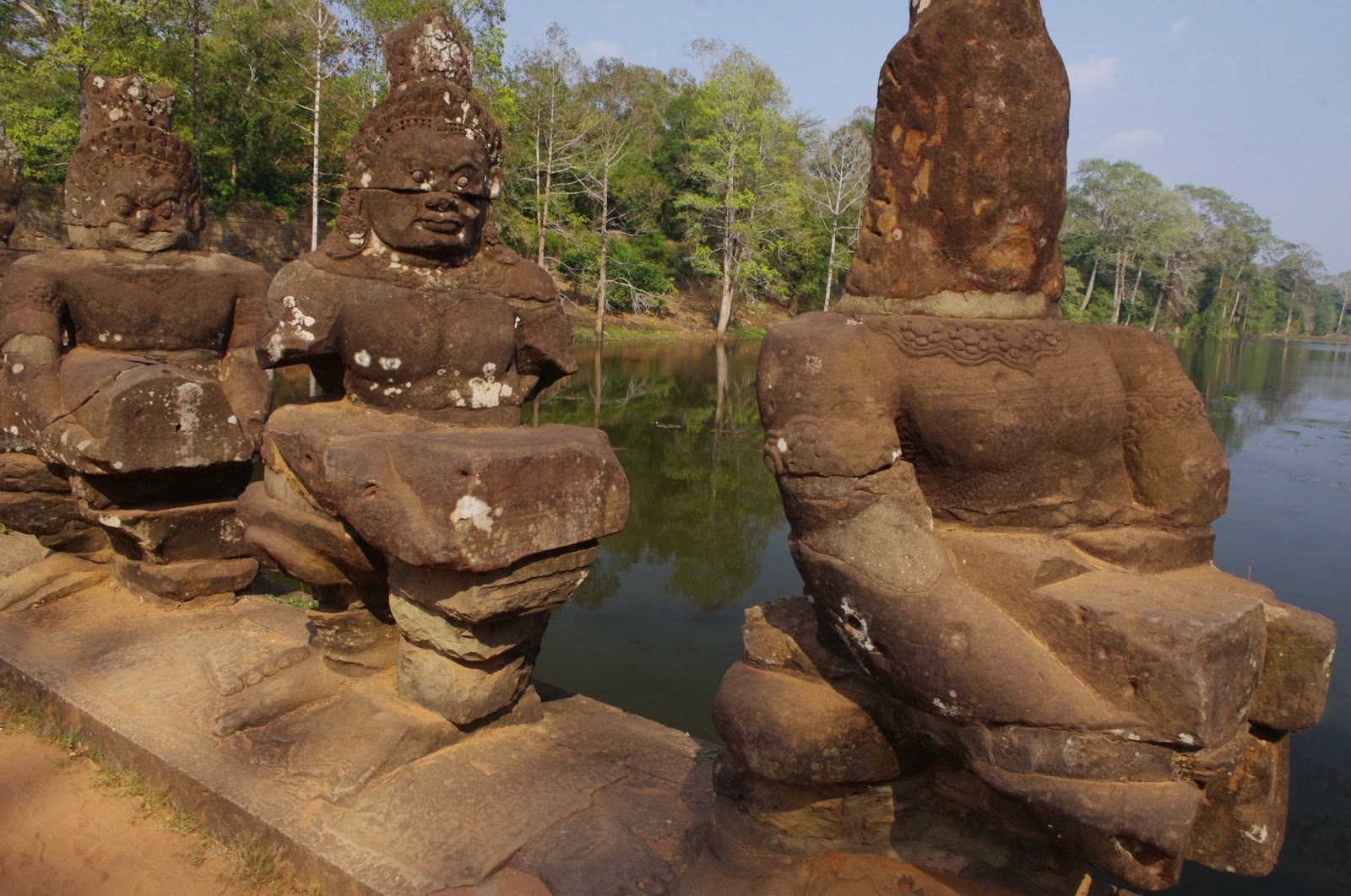
- A Nine-headed Naga from the moat of Angkor Thom -  Likely a depiction of the Prince of the Naga Vasuki, who also plays a key role in the cosmological myth of the Churning of the Sea of Milk. Giant Naga statues were frequently employed as guardians to the Temples to scare off intruders and wild beasts - Similar to Egypt, the Naga was also commonly employed as a symbol of Royal power. 
In ancient cultures, the Serpent was also a powerful symbol of the subterranean world and of telluric currents. As such, it may come as no surprise that Angkor allegedly occupies a very important spot in the Earth’s geomagnetic grid. According to researcher Jim Alison [6], Angkor is linked to a number of ancient sites through a network of coordinates of latitude and longitude. These sites include the Great Pyramid of Giza, Easter Island, Machu Picchu and the Nazca lines of South America, and the ancient cities of Petra, Persepolis and Mohenjo Daro. Also, Angkor is significantly located at 72° of longitude East of Giza (when one takes the meridian of Giza as the prime meridian to which is assigned longitude 0°), and 144° West of Easter Island – which is also 144° East of Giza.

Even though some of these speculations may seem too far-fetched, many other clues and symbols seem to link Angkor with ancient Egypt and the other major pyramid-building civilizations of antiquity. The very name of Angkor, supposedly a corruption of the Sanskrit Nagara (meaning City), bears striking similarities to the Egyptian hieroglyphic Ankh-Hor , meaning “The God Horus lives”. The giant Lingas located in most of the Angkor temples are reminiscent of the Egyptian Benben or the Greek omphaloi, significantly located at places of geodetic relevance. Also, similar to Egypt some divine architect was apparently involved in the construction of Angkor Wat and the major Angkorian monuments (Viskakarman, the architect of the Gods, who was later tributed divine honors just as his Egyptian counterpart, Imhotep).   
It is also a curious coincidence that about the same time when Angkor was built, an authentic surge of monumental construction took place in very distant parts of the World including the Gothic cathedrals of Europe and the great Maya pyramids (the latter bearing an uncanny and as of yet unexplained similarity to Cambodian pyramids, more than half a world away).   

Notes
[1] Graham Hancock, Santha Faiia, Heaven’s Mirror: Quest for the lost Civilization, Three Rivers Press, 1999
[2] Giorgio De Santillana, Herta Von Dechend, Hamlet’s Mill, Gambit, Boston, 1969
[3] Eleanor Mannikka, Angkor Wat, time, space and kingship, University of Hawai’i, 1998
[4] Shubash Kak, Time, space and astronomy in Angkor Wat, Louisiana State University, August 2001
[5] Jean-Pierre Lacroix, Robert Bywater, Khmer sacred Geography, http://ancientcartography.net/
[6] Jim Alison, The prehistoric alignment of World wonders, http://home.hiwaay.net/~jalison/


- Angkor Thom, the Bayon - Constructed as the state temple of King Jayavarman VII, the Bayon is one of the most iconic structures of Angkor. As a symbolic representation of Mount Meru and the ecliptic North Pole in the heart of the constellation Draco, it contains the sacred center of the whole Khmer empire. One can still feel a very deep spirituality amidst the candles and the gilded Buddha statues in the central room of the Bayon, which may have once hosted a giant linga in the form of a navel. 

- Phnom Krom - The small mountain-top temple of Phnom Krom  was used as one of the three main geodetic markers in the general layout of the ground plan of Angkor (the other two being Phnom Bakheng and Phnom Bok). The temple is now much ruined but still retains an aura of mysticism with its almost perfect East-West orientation and the large broken altars inside each of the three central towers. In ancient times, each altar would have contained a linga as a representation of the god Shiva and creative power.

- The great pyramid of Baphuon, in central Angkor Thom, rises almost as a perfect pyramid  with its several tiers and covered hallways. Once called the "Tower of Bronze", it rose even higher than the "Tower of Gold", that was the Bayon.  As a symbolic depiction of Mount Meru, it was believed that its underground portions extended as much underground as its tiers above ground, which is reminescent of similar traditions related to the Egyptian pyramids. 
- Neak Pean, meaning "The entwined serpents" - A small temple built on an Island inside the Jayatataka Baray. The temple, consisting of a small sandstone tower on a circular platform is sorrounded by giant sculptures of entwined serpents, which qualify also this temple as a symbolic depiction of Mount Meru, or the primordial mound, emerging from the waters of creation.  
- Preah Palilay - A small, 3-tiered pyramid off the beaten track in central Angkor Thom.  The pyramid, which was likely part of a group of three together with the Baphuon and the nearby Phimeanakas, is preceded by a monumental entrance gateway or Gopura and by a large seated Buddha statue. 
- The Northern Gate of Angkor Thom - The Northern Gate was one of 5 monumental gateways into  the great city of Angkor Thom (one in each cardinal direction, but two to the East). A giant face of King Jayavarman VII as Bodishattva Lokesvara was carved in each of the four directions above the massive corbel vault of the central archway. Each gateway was as much as 25 meters high, with walls 9 meters high and a moat 100 meters wide.


- Preah Khan - The great temple complex of Preah Khan is a large, sprawling complex comprising a monastery, several libraries and administrative buildings. A two-storey building supported by columns was either a library or a storage. The sculptured decoration and ornamentation is among the finest of any Angkor temples, with hundreds of Apsaras and sculptured doorways. Its modern name "Sacred Sword"is likely a reminescence of some ancient relic once kept inside this temple.
- Ta Prohm, "The ancestor of Brahma" - This vast temple is notable for the giant trees growing amidst the ruins . The temple was built by Jayavarman VII in the Bayon style, and shares with the Bayon much of the same "spirit of confusion" which is typical of the works and architectures of Jayavarman VII. 
- Chau Say Tevoda was one of two twin temples (the other being Thommanon) built immediately outside of the Gate of Victory to the East of Angkor Thom, on the royal road connecting the city to the great pyramid of Ta Keo. It was built as a Hindu temple in the Angkor Wat style and also dates to the reign of Suryavarman II. The temple contains 4 monumental gateways (Gopura) and is approached by a stone causeway flanked by libraries. 

- Banteay Kdei - Known as the "Citadel of Chambers", Banteay Kdei was a Buddhist monastic complex  built in the mid 12th to early 13th Century under the reign of Jayavarman VII. The temple was built in the Bayon style, similar to Ta Prohm and Preah Khan, but is considerably smaller. 

- Beng Mealea - The great jungle temple of Beng Mealea is still largely unrestored, providing a good picture of the effects of centuries of tropical weather on human construction. This vast temple, similar in size to Angkor Wat, was built some 60 Km from Angkor along the ancient road to Koh Ker. The temple is also encircled by a moat with Naga balustrades. Because of the temple's relative proximity to the sandstone quarries of Phnom Kulen, the stones used for its construction are considerably larger than those found at Angkor Wat or at many of the other Angkor temples. 


Angkor, The city of the Celestial Dragon (Part II)


Celestial diagrams at Angkor

- The Churning of the Sea of Milk - On the bridge leading to the South Gate of Angkor Thom across the moat stand 108 huge figures of Deva and Asura, 54 on each side. They are all pulling a giant 9-headed serpent along 9 Km of the outer perimeter of Angkor Thom. 

Shall one add Angkor to the list? It has five gates, and to each of them leads a road, bridging over the water ditch that surrounds the whole place. Each of these roads is bordered by a row of huge stone figures, 108 per avenue, 54 on each side, altogether 540 statues of Deva and Asura. And each row carries a huge naga serpent with nine heads. Only, they do not "carry" that serpent, they are shown to "pull" it, which indicates that these 540 statues are churning the Milky Ocean, represented (poorly, indeed) by the water ditch, using Mount Mandara as a churning staff, and Vasuki, the prince of the Nagas, as their drilling rope. The whole of Angkor thus turns out to be a colossal model set up for "alternative motion" with true Hindu fantasy and incongruousness to counter the idea of a continuous one-way Precession from west to east.
[G. De Santillana, H. Von Dechend, Hamlet’s Mill (1969), p. 163]

                According to Hancock (quoting from Santillana and Von Dechend’s masterpiece book Hamlet’s Mill), the whole city of Angkor was built as a colossal diagram of precession to embed specific astronomical numbers and constants.  One of these “cosmological myths” portrayed at Angkor is the famous Churning of the Sea of Milk. It covers a bas-relief almost 50 meters long inside Angkor Wat’s eastern gallery. 92 Deva and 88 Asura (for a total of 180 figures) pull the serpent Vasuki for one thousand years around Mount Mandara, which serves as the axis of the World and (according to Santillana and Von Dechend), the ecliptic North Pole around which the constellations revolve as a consequence of precession.  More recently, the Angkor expert Eleanor Mannikka has pointed out that even the division in 92 Deva and 88 Asura very accurately marks the number of days between the Winter solstice and the Spring equinox in March and the number of days between the Summer solstice and the equinox respectively. Also, the whole of Angkor Wat would have functioned as a giant calendrical clock, providing a 3-days warning of the Spring Equinox: An observer along the Western causeway would have seen the sun rising exactly on top of the central tower of Angkor Wat on each of the 3 days preceding the Equinox and then on the Equinox day from a different position moved more towards the center of the platform. Similarly, the lateral towers of the Western gateway would have served as solstitial markers for an observer located right outside the bridge main entrance.
- The Churning of the Sea of Milk - Bas-relief from the Eastern gallery of Angkor Wat. 92 Deva and 88 Asura pull the serpent-king Vasuki for one thousand years around Mount Mandara, resting on the shell of a giant turtle, itself an avatar of Vishnu. Vishnu and Indra keep the mountain stable during its rotation and prevent it from sinking into the Milky Ocean. From the "incomparably mighty churn" the Apsaras - celestial dancers, are born, and the Amrita, the nectar of immortality is recovered. In turn, demons and gods will contend for one more thousand years the possess of the nectar of immortality.
                While this can certainly be no coincidence, the ancient builders of Angkor Wat also embedded a wealth of astronomical information in the main dimensions of their temples. First of all, as Mannikka observes, the main axial measurements of the temple as taken from the moat and along the western causeway yield, with almost exact precision, the values of the Hindu cosmological cycles of 432,000; 864,000; 1,296,000; 1,728,000 years (here expressed in Khmer cubits of 43.54 cm). Also, the sum of the lengths of the axes of the perimetral wall of Angkor Wat (divided by 12) yields a length of 365.24 cubits, which is the same as the length in days of the solar year. The same figure for the outer encircling wall (divided by 24, as the number of lunar half-phases in one year) yields 354.36 cubits, which is the length (in days) of the lunar year. [3]
According to another scholar, the historian and mathematician Shubash Kak, Angkor Wat consists of at least three astronomical and architectural units which are part of single giant cosmic diagram [4]:

1. The central sanctuary (that is Mount Meru), symbolizing the celestial North Pole, the Earth axis and the spring Equinox
2.  The outer corridors and concentric galleries, which symbolize the ecliptic and the Earth’s and planetary orbits, the cycles of the moon, the constellations and the solar and lunar years
3.    The four axes of the temples, which represent the cosmic ages and the cycles of time.

- Angkor Wat - King Suryavarman II ("Shield of the Sun"), depicted in the Northern gallery of Angkor Wat in front of a delegation of foreign dignitaries. Suryavarman, who was himself an usurper to the throne, may have built Angkor Wat as a way to provide legitimacy to his own reign. The peculiar western orientation of the temple suggests he may have conceived Angkor Wat as his own monumental tomb or funerary temple - as a vehicle to reach immortality amidst the Gods -
The most strikingly astronomic monument is however located a mere hundred meters from Angkor Wat, on the mountain Phnom Bakheng. It is a 5-tiered pyramid, 76 meters wide at its base, surmounted by 4 towers and a central sanctuary. A total of 104 smaller towers stand on the lower terraces, which add up to 108 once the 4 towers on the top are added. This makes 27 towers on each side, the same as the number of days in a lunar month. In turn, the lateral towers and the central sanctuary mark the position of the Sun at the two Solstices and at the Equinox. Of the 60 towers that stand on the upper 5 terraces, there are 12 on each terrace, the same as the number of years in the Jupiter cycle, considered the base of the Khmer sacred calendar. Not surprisingly Phnom Bakheng has been described as an astronomic calendar in stone. But the same may be said of other famous Angkor monuments, such as the Bayon, with its 54 towers, and the Pre Rup, which also contains a total of 27 towers.  

Moving further into the field of Earth-Sky analogies, independent researchers Jean-Pierre Lacroix and Robert Bywater believe they have found proof of gigantic planetary diagrams on the ground of Angkor, modeled after ancient Hindu astronomic systems.  The theory of Lacroix and Bywater is too complex to be treated in sufficient detail (a more detailed explanation, complete with figures and diagrams, may be found on their own website http://ancientcartography.net/), so only the outline will be given here. As the two authors carefully explain on their website, they believe to have developed “a theory about the relationship between the locations of the principal Khmer monuments (and in many instances their orientation and internal measurements) and components of enormous Indian planetary diagrams “drawn virtually” on the Angkorian ground using the parameters of the “Midnight System”.
The “midnight system” is in fact one of two geocentric models proposed by the Hindu astronomer and mathematician Aryabhata in the early 6th Century AD. The model allows to predict with a high degree of accuracy the exact position of the inner and outer planets (including that of the Sun and the Moon) on a specific date, based on the intersection of a circle called deferent (centered on the observer) and a combination of two epicycles called Manda and Sighra. The two authors believe they have found proof of the knowledge of the “midnight system” by the ancient Khmer in an inscription from the temple of Banteay Srei referring to the position of the planets during a highly significant planetary alignment that was recorded by Khmer astronomers on the midnight of April 22nd, 967 AD. On that date the planets were clustered around the same portion of the night sky within the Pisces constellation as they were at the beginning of the Kali Yuga – the last cycle in Hindu cosmology – which supposedly began on February 17th, 3,102 BC.  The origin of this planetary model may indeed be extremely ancient, as it is found already in pre-Vedic inscriptions and astronomical recordings from the Harappan culture at Harappa and Mohenjo-Daro.  

The ancient Khmer, however, did not clearly limit themselves to recording astronomical dates, but wanted to portray them through colossal diagrams on the ground as part of their own sacred geography. Astonishingly, Lacroix and Bywater believe that “The Khmer kings moved their successive capitals across Cambodia for various political reasons, but we suggest they wanted also, in some cases, to obey the rules of sacred geography related to planetary diagrams or, conversely, to use a new location to create or complete a planetary diagram”; thus providing an explanation for the unexpected surge in building activity that characterized the beginning of the Khmer empire. According to the two authors, this set of planetary diagrams that covered the whole of the ancient Khmer empire, were brought to light by temples built on key locations, which in turn “reveals capacities, in the fields of astronomy, land-surveying and cartography, which exceed by far the know-how and accuracy previously attributed to Middle-Age scholars”.

By establishing their prime meridian across the sacred mountain of Phnom Bakheng, the ancient Khmer were able to carry out a comprehensive survey of their vast empire, locating cities and monuments according to a celestial design. As an example, the two authors cite the anomalous orientation of the ancient site of Preah Khan of Kampong Svay, which is oriented 28° East from true North. This is along the same orientation of a line connecting the center of the Sighra epicycle used to describe the position of Saturn with an imaginary observer located on the hill of Phnom Bok nearby Angkor. Also, when measurements are taken using the krta yuga of 752.46 meters as the ancient Khmer land surveying unit, the distances between the neighboring as well as the more distant sites surprisingly yield exact integer numbers which are multiples of the main planetary dimensions and the measures of the epicycles. [CONTINUED IN PART III]

- The small pink sandstone temple of Banteay Srei -  located some 30 Km North-East of Angkor, is rightfully considered the masterpiece of Khmer sculpture and artistic ornamentation. An inscription found on a stele inside the temple contains the description of a planetary alignment that occurred on April 22, 967 AD. 
- Angkor Wat - The central tower of Angkor Wat, conceived as a symbolic depiction of Mount Meru. Its tip stands at over 65 meters high - twice the height of the Tower of London - and was once gilded in gold and bronze that would have made it shine in the sun like a gold-capped mountain. 
- Angkor Wat - From underneath the base of the Bakan, the great central sanctuary of Angkor Wat,  one can notice the different construction layers and the inner laterite foundations of the mountain-temple. The ancient Khmer used laterite for the bulk of their monuments, saving the much more precious sandstone for the casing and the bas-reliefs. While laterite could be sourced locally, as it is a stone typical of humid, tropical climates, sandstone had to be carried overland for more than 50 Km from quarries located in the Kulen mountains. 
- Angkor Wat - A Buddhist statue guards the entrance to the inner sanctuary of the central tower of Angkor Wat, which was once open to the winds. From there, a deep pit descends down to the foundations of the monument to what is believed was the burial chamber of King Suryavarman II, the builder of Angkor Wat. 

- Angkor Wat - A moat sorrounds Angkor Wat on all four sides, and is only crossed by bridges towards the Western and Eastern gateway. From the gigantic causeway, an ancient observer could have looked at the Sun rising straight upon the central tower and each one of the two lateral towers of the Western gateway on the dawn of the spring Equinox and on the two Solstices. The measures of the moat and the outer walls also embed significant astronomical constants related to the duration of the Hindu cycles of time. 

- Angkor Wat - The outer pillared galleries of Angkor Wat contain several Shivaitic and Buddhist statues . The ancient Khmers, who did not know the use of the vault, covered their passages and corridors with impressive corbel vaults which are strongly reminescent of Maya or the early-Egyptian pyramid age architecture -

- Angkor Wat - The main temple of Angkor Wat, with its 5 towers rising high in the sky, was conceived as a terrestrial depiction of Mount Meru and its companion mountains. The very steep stairways and natural-looking architecture were intended to represent the mountain range sheltering the abode of the Gods on Mount Meru. 
- Angkor Wat - The lower galleries of Angkor Wat contain some 800 meters of bas-reliefs depicting mythological scenes from the Ramayana and the Mahabharata, including the siege of Lanka and the battle of Kurukshetra. Other panels depict the famous "Churning of the Sea of Milk", as wells as scenes from the Hindu heaven and hell and the military campaigns of Suryavarman II against the Cham. 


Angkor, The city of the Celestial Dragon (part I)

Angkor, The city of the Celestial Dragon

- Angkor Wat, as seen at sunrise from across the moat encircling the Western entrance - One can see in the distance the five towers of the Bakan - the central sanctuary - symbolizing Mount Meru and its four companion mountains - 

Angkor, the capital of the great Khmer Empire between the 9th and the 14th Century AD, was the largest city in the World of its time with a population of over one million people. For a long time pictured as the heart of darkness in one of the 20th Century’s most gruesome genocides, its ruins have only since a few decades resurfaced from their jungle tomb in remote Cambodia as one of the world’s premiere tourist destinations.
The ruins of Angkor cover an area of more than 600 Km2, a city the size of Los Angeles, larger than New York or London, on the northern shores of Lake Tonle Sap, in what is nowadays Cambodia. Over a span of slightly more than three centuries, over 700 temples were built within its walls, ranging from mere brick towers to gigantic sandstone pyramids.  
Ever since its re-discovery by the Europeans in the 19th Century, Angkor has become the archetype of the lost city, with gigantic threes looming sinisterly from crumbling walls and cavernous temples. In fact, Angkor was never lost and continued to remain an active site of pilgrimage for the local Buddhist population even centuries after its collapse in the mid-14th Century. It is true however that while a few of the major temples remained vital throughout the Centuries; the vast majority of the ancient city was soon reconquered by Nature and vegetation, turning much of it into a dilapidated ruin.  All in all, Angkor teaches a very interesting lesson on how quickly nature can claim the works of man.

Angkor was forgotten – at least to the West – and even the Khmers themselves (or their descendants), plunged into a state of barbarism through conquest and an impoverished agriculture, seemed to retain little if no memory of the city or its builders. Very much to the entertainment of European travelers, they claimed the ruins had been built by Angels or by a race of giants in a single night. Yet the great Khmer empire was no civilization of antiquity: Angkor flourished at the same time as the European cathedrals and the remnants of its once glorious civilization extended very much into Renaissance.

The beginnings of Angkor are no less mysterious. A stele from Ak Yum, near the Western Baray, bears an inscription with a date of 713 AD by a certain Queen Jayadevi, the earliest ever found. Very little is known of the history – let alone the prehistory – of Angkor before its first great king, Jayavarman II, about 802 AD. After spending much of his early life in the company of a mysterious and powerful monarch known in Khmer inscriptions as the “King of the Mountain”, who probably ruled from Java, Jayavarman II founded the cult of the Deva-Raja (God-King or King of the Gods) and proclaimed himself without much modesty Chakravartin, that is “King of the World”, through a rather obscure magical ritual performed on the sacred mountain of Phnom Kulen, some 50 Km north-East of Angkor.   
Before settling in what was to become their greatest city at Angkor, the Khmers founded several ephemeral capitals, all within 100 Km from Angkor, as if looking for an ideal site where to establish their capital. The first of those cities was on the Kulen mountains. From there the capital was transferred at Indrapura (whose exact whereabouts are unknown), and then in a new city called Hariharalaya (present day Roluos). The successors of Jayavarman II established new cities at Yasodharapura, the first city of Angkor, centered around the holy mountain Phnom Bakheng, and at Koh ker under Jayavarman IV.  
At the beginning of the 13th Century, the Khmer capital of Angkor Thom was surrounded by an impressive moat running over 100 meters wide along the 9 Km walls. Two giant reservoirs, as much as 8 by 2 Km wide, called Baray, were dug to the East and West of Angkor Thom. To the South stood the equally impressive Angkor Wat, built by Suryavarman II as a model depiction of Mount Meru, a temple that claimed to be the largest single religious building on Earth.

An hypothesis that sparkled much interest over the last decade was proposed by Graham Hancock and John Grigsby (then a Ph.D. student working for Hancock on his book “Heaven’s Mirror”) in their stellar correlation theory with the constellation Draco [1]. According to Hancock and Grigsby, over 15 of Angkor’s pyramids and temples aligned with remarkable accuracy to stars in the constellation Draco, while significant stars from neighboring constellations such as Cygnus and Corona Borealis were also marked on the ground. What was perhaps even the more surprising was that the diagram drawn on the ground of Angkor appeared as if turned “upside-down” with respect to its celestial counterpart in Heaven. Hancock and Grigsby estimated this could be due to precession and that a perfect alignment with the stars of Draco in the right position would have only occurred before dawn on the spring Equinox around 10,450 BC; when Draco was at its lowest culmination at Angkor. Interestingly, the great temple-pyramid of Angkor Thom, the Bayon, placed exactly in the center of the Khmer capital and acting as the mythical omphalos or navel of the Khmer empire, would have taken the position of the ecliptic North Pole in Hancock’s celestial diagram. [Continued in Part 2]

- A plan of the city of Angkor with its major monuments - The small hilltop temples of Phnom Bok, to the North-East and Phnom Krom, to the South, are not included in the map -


- Changing capitals - The pyramid mountain of Bakong, built as an imitation of Mount Meru in what is today's Roluos. The pyramid would have been the center of the new city of Hariharalaya, located 15 Km South of Angkor close to a vast artificial Baray or reservoir. The pyramid of Bakong, together with the nearby temples of Lolei and Preah Ko, also resting on massive laterite foundations, is believed to be a depiction of the Corona Borealis in the celestial diagram of Angkor outlined by Hancock and Grigsby.

- Changing capitals - The first city of Angkor at Yasodhapura, on top of the Phnom Bakheng. The much dilapidated pyramid was believed to have once served as a veritable "calendar in stone" with its 108 smaller towers - Currently, the pyramid is undergoing extensive restoration and reconstruction. Phnom Bakheng, together with the nearby hills of Phnom Bok and Phnom Krom (all within the same line of sight), was one of the few natural features that would have called for the attention of the ancient surveyors when laying out the ground plan of Angkor on the ground.

- Changing capitals - Pre Rup, the center of a supposed Eastern City located close to the Eastern Baray. Pre Rup was conceived as his state temple by King Rajendravarman and dedicated about 961 AD - The name of Pre Rup literally means "turn the body" and was probably associated to ancient cremation rituals taking place on the top platform of the pyramid. A similar temple, called the East Mebon, was built by the same King Rajendravarman as an island in the middle of the Eastern Baray and dedicated to the memory of the ancestors.

- Changing capitals - Koh Ker, the site of an ephemeral capital built by King Jayavarman IV over  20 years starting in 921 AD. The great pyramid of Prasat Thom was entirely encased in sandstone and with an height of 37 meters is the highest free-standing structure in the whole of the Khmer empire. Its seven tiers were once crowned by a massive linga supposed to be over 7 meters hight. Similar monolithic linga have been found at Koh Ker weighting as much as 100 tons.
Among the many ruined temples that comprise the ancient city of Lingapura (Koh Ker), Prasat Prom is notable for its crumbling towers on a high laterite platform, strangled by giant trees. 
- Changing capitals - The great pyramid of Ta Keo was built as his own state temple by Jayavarman V in  the year 975 AD, after abandoning his father's supposed Eastern City at Pre Rup. The pyramid appears of especially massive construction and shows evidence of at least two different stages of construction 


- Changing capitals - The sanctuary towers on top of the Ta Keo pyramid  (whose name means the "Crystal tower" or "The tower of Glass") were left unfinished and largely undecorated, giving them a particularly massive appearence. According to inscriptions found near the base of the Pyramid, construction was abandoned after a lightning struck the pyramid causing the King and workers to flee in terror. Notably, the upper sanctuary towers are built of a kind of sandstone, called Greywacke, which is significantly harder than the relatively soft yellowish sandstone used for the base of the pyramid. The greenish Greywacke also contains a large quantity of Quartz which gives it a high magnetic susceptibility.   


- Changing capitals - The great temple of Bayon, built by King Jayavarman VII in the early 13th Century, was amongst the latest temples ever built at Angkor. Jayavarman VII moved the capital to Angkor Thom, which he encircled within a 9 Km long wall pierced by 5 gates (one in each cardinal directions, and two to the East) and a moat over 100 meters wide. He built the Bayon as his state temple in the heart of Angkor Thom, at a place which symbolically represents the ecliptic North Pole and the heart of the celestial dragon. Each one of the 54 towers bears a face of the Bodishattva Lokesvara, which many identify with Jayavarman VII himself.